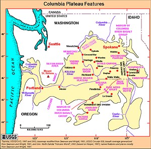
The Columbia Plateau, also known as the Columbia Basalt Plain, is the prominent geographic feature of the interior Columbia River Basin. The plateau formed between 6 million and 16 million years ago as the result of successive flows of basalt. Its northern border is marked by the Columbia River and the mouth of the Okanagon River. On the south, the plain includes the drainage of the Deschutes River in Oregon. On the east the plateau includes the Camas Prairie of central Idaho, and on the west it runs to the foothills of the Cascade Mountains. The Columbia River makes a looping S-curve through the central Washington part of the Columbia Plateau.
In a river basin that is mostly mountains and steep valleys, the Columbia Plateau is an area of flat land and gently rolling hills cut by the sometimes steep river canyons of the Columbia and its tributaries. It is a roughly triangular-shaped area about 250 miles on a side. On its fringes the elevation of the plateau is about 4,000 feet (1,219 meters) above sea level, and at its lowest point it is about 400 feet (122 meters). The Columbia Plateau is the major agricultural region of the interior Columbia River Basin and includes the cities of Ellensburg, Wenatchee, Yakima, Moses Lake, Walla Walla, Pullman, and the Tri-Cities of Washington (Pasco, Kennewick, Richland); Pendleton, Umatilla, and The Dalles, Oregon; and Moscow and Lewiston, Idaho.
The journals of Lewis and Clark briefly note the Plateau. On Sept. 18, 1805, Clark wrote: “...from the top of a high part of the mountains…I had a view of an emence Plain and leavel country to the SW. & West.” After their difficult crossing of the Bitterroot Mountains, the sight of the plain “greatly relieved the spirits of the party,” he wrote in the journals for the next day.