


Hydropower is electricity produced at dams by water falling through turbines. Hydropower has a long history in the Pacific Northwest and particularly in the Columbia River Basin. The first hydroelectric dam in the Pacific Northwest was built in Spokane in 1885. An entrepreneur named George Fitch received a city franchise to light several street corners in downtown Spokane near the Spokane River. He installed a small dynamo, powered by the river, in the basement of a flour mill and sent electricity to a dozen arc lights a short distance away. Four years later, in 1889, the first long-distance transmission of electricity in the Northwest began in Portland, where a direct-current line was built from a small hydropower plant at Willamette Falls to light street lights downtown, a distance of about 13 miles.
Beginning in the late 1930s, the production of hydropower was the primary instrument of economic change in the West, according to historians Dorothy Johansen and Robert Gates. Nowhere in the West, or elsewhere in the nation for that matter, is hydropower as important as an instrument of economic change or factor in the electricity supply as in the Pacific Northwest. And of all the hydropower produced in the Northwest, the largest share is produced at dams on the Columbia River and its tributaries. Fully 40 percent of the electricity used in the Northwest is generated by federal dams in the Columbia River Basin and sold by the Bonneville Power Administration. The percentage of hydropower increases when non-federal dams in the Columbia River Basin are included, and it rises again with the incorporation of dams in the Canadian portion of the Columbia Basin — B.C. Hydro sells some power into the U.S. Northwest — and the addition of federal and non-federal dams outside the basin.
Federal dams in the U.S. Columbia River Basin generate, on average in a year, 8,664 megawatts of electricity, or enough power for approximately 4,938,480 average homes (at 570 homes per megawatt) or nearly eight cities the size of Seattle. Non-federal dams in the Columbia River Basin produce, on average in a year, 5,368 megawatts, or enough electricity for approximately 3,059,760 homes or nearly five Seattles. Hydropower dams in the Canadian Columbia River Basin generate, on average in a year, 2,572 megawatts, but nearly all of that is consumed within the province.
The Columbia River is uniquely situated as a hydropower river, in that it flows through multiple mountain ranges on its 1,214-mile journey to the sea, and these engorge the river and its tributaries with millions of acre-feet of snowmelt runoff every year. Also, the Columbia drops at a fairly uniform rate of about two feet per mile, and much of its course is through solid rock, carved by repeated floods at the end of the last Ice Age. The rocky canyons provide excellent footing for dams. But the river’s primary asset also provided the greatest challenge to hydropower development, in that while the volume of water was great the flow fluctuated wildly through the year — high in the spring and early summer, low in the late summer and fall. The question for hydropower planners, then, was how much power could the Columbia River produce, given its yo-yo annual flow pattern, and thus, how many generators could those flows support? The region could not rely on dams that produced a lot of power for only part of the year. Power production needs to be stable throughout the year. What, then, was the base flow, the flow that always would be available?
In January 1937 nature cooperated by producing an unusually low runoff. That month, the mean flow of the Columbia, measured at The Dalles, Oregon, was 39,160 cubic feet per second, the lowest on record (the record dates to the water year of 1927-28). In the approach to water power development employed by the U.S. Geological Survey at the time, the minimum natural flow of a river was the basis for hydroelectric planning. In 1937,the formal record at The Dalles was only 10 years old, but informally it was acknowledged that the year was unusually dry. Using 1937 flows as a base, only three generators could have been built at Bonneville Dam. The Corps of Engineers, which was in charge of Columbia River hydropower planning, decided on six generators (of 43 megawatts each), on the basis of the size of the pool behind the dam plus the addition of water that would be released from behind Grand Coulee Dam 451 miles upstream. If more water could be stored, more generators could be built. But the flow pattern in the river was a problem. By 1937, the highest monthly mean flow recorded at The Dalles was 1,200,000 cubic feet per second in June 1894, which made the ratio of the record high flow to the record low flow about 30:1. The giant reservoir behind Grand Coulee, however, helped legitimize the construction of additional dams downstream.
Today there are 14 dams on the mainstem Columbia River, three in British Columbia and 11 in the United states. Five of the American dams are non-federal. In 1953, President Dwight Eisenhower shifted the nation’s power policy from one of federal dam construction to one of encouraging local utilities to build dams on major rivers. Three public utility districts in central Washington, in partnership with investor-owned utilities, took advantage of this shift and built four huge dams on the Columbia during the 1950s and 1960s: Priest Rapids (originally authorized as a federal dam), Wanapum, Rocky Reach and Wells. The Bonneville Project Act authorized Bonneville to transmit power from non-federal dams, ensuring a coordinated power production system in the Columbia River Basin.
The construction of additional storage dams in the Columbia River system, including the dams built in British Columbia under the Columbia River Treaty of 1964, ultimately would reduce the ratio of highest to lowest flows to about 4 or 5:1, and this would vastly increase the hydroelectric potential of the basin by allowing flows to be regulated and stabilized throughout the year. Still, systemwide only about 40 million acre-feet of water can be stored, which is about 22 percent of the average annual runoff of 180 million acre-feet.
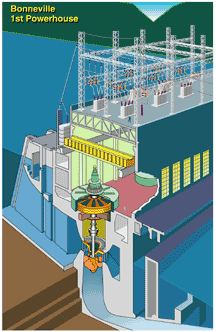
Photo: U.S. Army Corps of Engineers.