


The roughly horseshoe-shaped falls 14 miles upstream from present-day The Dalles, Oregon, were one of two important Indian fishing and trading places on the Columbia River, the other being Kettle Falls. Archaeological evidence, including excavated middens of salmon bones, suggests that humans fished at Celilo Falls and other locations between there and The Dalles for more than 10,000 years.
In geologic history, Celilo Falls was carved by the repeated floods that coursed through the Columbia River Gorge at the end of the last ice age, creating a roughly 15-mile stretch of chutes, rapids, eddies, small islands and, as a result, ideal fishing sites in the arid rain shadow of the Cascade Mountains. In native oral traditional stories, the falls are the remains of the dam built by the five Swallow Sisters to block salmon from returning upriver. Coyote tricked the sisters, destroyed the dam, and the resulting flood left the falls and the rocky, contorted riverbed downstream. As punishment for keeping salmon from the people, Coyote ordered swallows to fly up the river each spring to announce the return of salmon.
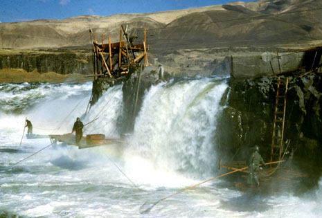
Celilo Falls was the site of both permanent and temporary Indian residences. Indians fished at proprietary sites that had been used by generations of the same families; sometimes these sites were loaned to visiting tribes. Indians fished primarily with dip nets, which are nets affixed to hoops mounted on long poles — 20 feet and longer. Fishers would stand on the rocks or on platforms built over the water and dip the nets into the base of a falls. The 10-mile stretch of river between The Dalles and Celilo Falls was the greatest fishery on the river, ethnologist Eugene Hunn writes in Nch’I Wana, his study of mid-Columbia Indians. While the salmon and steelhead runs usually peaked for only a few days at a time in the spring and early summer, the rocky chutes through which the river poured in this area made for effective fishing, and catches of several hundred fish per day per fisher were common.
Lewis and Clark noted the great quantities of salmon and steelhead caught at Celilo and other fishing areas nearby on the river. On Saturday, April 19, 1806, on their return journey upstream from the Pacific, the explorers witnessed a ceremony at a Wishram village on the north shore near the falls honoring the first salmon caught that year. According to the explorers’ journals, “there was great joy with the natives last night in consequence of the arrival of the Salmon; one of these fish was caught; this was a harbinger of good news to them. They informed us that these fish would arrive in great quantities in the course of about five days.” The explorers wrote that the first fish was divided into pieces and distributed to the children of the village. Lewis and Clark described Celilo Falls as the “great mart” of the territory, as it was a trading hub for Indians of the region and was at the junction of important trails.
Eventually non-Indian fishers began using the falls, particularly as a site for fish wheels. These captured huge quantities of salmon for canneries that were built adjacent to the falls and downriver at The Dalles. Inevitably, as well, the falls, and access to the falls, became a lightning rod for conflicts between Indian and non-Indian fishers. Several subsequent lawsuits, which challenged Indian fishing rights reserved by the tribes in treaties with the United States in 1855, established important legal principles that are at the foundation of modern fishery law. The treaty rights never have been extinguished.
Today, Celilo Falls is under water, a victim, like Kettle Falls before it, of the federal government’s construction of massive, multi-purpose dams on the Columbia River. Kettle Falls disappeared under Lake Roosevelt behind Grand Coulee Dam in 1941; Celilo Falls disappeared under the water behind The Dalles Dam in 1957.
For Celilo Falls, the beginning of the end came with Congressional authorization of The Dalles Dam, in 1950. The potential impact of the dam on Indian fishing and salmon raised some concern among the public. In January 1951, Herb Lundy, an editorial writer at The Oregonian newspaper in Portland, asked Samuel J. Hutchinson, acting regional director of the U.S. Fish and Wildlife Service, about the impacts The Dalles Dam would have on salmon. In a memo to his files, Hutchinson later wrote, “I stated that the beneficial effects would compensate for the detrimental conditions that exist there at present. In brief, it would be easier for the fish to go over a ladder in the dam than to fight their way over Celilo Falls. The dam would eliminate the historic Indian fishery, but more fish would reach the spawning grounds in better condition.”
Lundy’s editorial appeared the next day, January 17. He wrote that while the region and the nation needed new sources of electricity, it would be “tragic and self-defeating for Congress to force the Pacific Northwest to sacrifice other resources on the altar of power development when this is not necessary.” Dams should be built “in the least harmful way” to fish, according to the editorial. At the time, the government was investigating construction of dams on the lower Snake River, as well, and Lundy opined that none should be built there until the government fulfilled its promises to Oregon and Washington “to build up the salmon populations of the lower Columbia tributaries.” Nonetheless, the newspaper supported construction of The Dalles Dam because “it would be the least damaging so far as salmon are concerned.”
Federal policy at the time supported the construction of dams and the replacement of fish losses through hatcheries — in the case of Columbia River salmon primarily through hatcheries on tributaries of the lower Columbia downstream of Bonneville Dam. In this paradigm, Celilo Falls was an impediment to both progress in the form of hydroelectric development and to the fish. By building hatcheries downriver, so the government assumed, fish losses at the dam would be mitigated and more fish would return to spawn naturally upstream. Only the falls would be lost; the fishery could continue. Perhaps it even would be enhanced because the impediment of the falls would be eliminated. The Oregonian accepted the logic, describing Celilo Falls as “ancient” and the fishery as “colorful” and “historic” but reasoning with the government that fish ladders at the dam would provide an easier route for adult fish than the falls, “in which many are injured and die without spawning.”
The irony in the paradigm was the focus on the survival of upstream-migrating adult fish at the falls, a natural impediment that salmon and steelhead successfully passed for tens of thousands of years, and not on fish passage at dams, where juvenile salmon and steelhead can be injured or killed by the spinning turbines and the tremendous water pressures they produce. At the time, it was understood that dams killed juvenile fish, but the matter had not been studied thoroughly on the Columbia. That was changing. In 1947, biologist Harlan Holmes, who was employed by the U.S. Army Corps of Engineers to study fish passage at Bonneville Dam, described some turbines as “literal sausage grinders.” In 1952, Holmes estimated that Bonneville Dam killed 15 percent of all juvenile fish that passed through. In 1953 he advised the Corps’ acting regional supervisor in charge of river basin studies that planned reductions in river flows, which were controlled upriver at Grand Coulee Dam, should be coordinated with periods of reduced fishing at Celilo Falls, but that the Indians should not be told in advance. Otherwise, “the Indians may intensify their [fishing] efforts during the low flow period,” he advised.
Over time, the government’s primary source of funding for fisheries conservation on the Columbia, the Mitchell Act, focused fish production at hatcheries that were built downstream of Bonneville Dam. This was a blow to Indian people, who rightfully expected the government to live up to its promises to conserve their fish and fisheries, particularly the historic fishery at Celilo Falls. Hatcheries eventually were built in the Columbia Basin above Celilo Falls, but not until long after The Dalles Dam had inundated the falls and its fishery.
The four Treaty tribes (Nez Perce, Umatilla, Warm Springs, and Yakama) each entered into settlement agreements with the United States for the destruction and inundation of fishing sites due to the construction and operation of The Dalles Dam. In exchange for granting the U.S. a flowage easement over the sites and forgoing litigation, each tribe received a payment from the federal government. The amounts totaled $26,888,395, divided this way: $15,019,640 to the Yakama Nation; $4,4451,784 to the Warm Springs Tribes; $4,616,971 to the Umatilla Tribes; and $2,800,000 to the Nez Perce Tribe. Importantly, the tribes did not give up their treaty rights to fish at their “usual and accustomed” places. Although John Day Dam was authorized in the same legislation as The Dalles Dam, the River and Harbor Flood Control Act of 1950, and the fishery impacts of dam construction downstream of McNary Dam were discussed in a 1948 document prepared by the Portland District of the Corps (“Review Report on Columbia River and Tributaries”), there was no compensation to the tribes for the impacts of John Day or McNary dams. See, for example, “The Indian Fishing Problem," in Appendix L of the report at page 2567). See also Appendix P of the same document, “Fish and Wildlife in the Columbia River Basin,” beginning at page 2879. Perhaps this is because the government assumed the treaty fishery would end after Celilo Falls was flooded.
On Page 2880 of Appendix P, the potential impact on fish from construction of The Dalles and John Day dams is recognized:
The effects on the fish runs would depend on the length of delay, and it is conceivable that during some years there might be a serious loss to the fishery. In addition to their direct effects on the anadromous fish populations, these two dams would be a part of the series of obstacles in the main migration route of the majority of the upstream and downstream migrating salmonid fishes. When they, together with already authorized dams, are constructed, salmon spawning in the upper reaches of the Snake River would have to pass eight huge dams, both on their-upstream and downstream migrations, and the cumulative effect of the series of dams might be much greater than eight times the effect of a single dam.
Indian fishing, at least in the abstract if not in reality, was a problem for the United States government. A 1952 report by the Portland District of the Corps of Engineers entitled “Special Report on Indian Fishery Problem, The Dalles Dam, Columbia River, Washington-Oregon," says (Page 4):
“The construction of the dams contemplated on the Columbia River, between Bonneville Dam and McNary Dam, would create many difficult and vexatious problems in connection with the Indian fishery on the Columbia River. This was especially true of The Dalles Dam which would inundate Celilo Falls, the most important and widely known fishing station used by the Indians on the Columbia River.”
The report recognized the impact The Dalles Dam would have on the fishery at Celilo, but concluded that construction was justified because "... large numbers of businessmen and others interested in the full development of the Northwest water resources feel that normal progress and industrial development warrants the dam construction even though it will adversely effect [sic] the Indians." (Page 24.)
On April 20, 1956, the last of the First Salmon rites was conducted at Celilo Village, which was located on the Oregon shore at the falls. The Dalles Dam was nearing completion downriver, and within a year its flood gates would be closed and a reservoir would flood Celilo Falls. April 20 was a Sunday. Author Anthony Netboy witnessed the ceremony and later wrote that the day was warm and sunny and that hundreds of Indians gathered for the ceremony. Chief Tommy Thompson of the Wyam Tribe, who lived at Celilo Village, presided. He was said to be more than 100 years old. Thompson blessed the first fish and then made an emotional speech in his tribe’s language. According to Netboy, Thompson was weeping before he finished, and while Netboy could not understand the Wyam language, he wrote that he could imagine the feelings that inspired the chief as he realized the ancient falls soon would be flooded. Netboy also saw tears in many of the others gathered at the ceremony that day.
The four Treaty tribes (Nez Perce, Umatilla, Warm Springs, and Yakama) each entered into settlement agreements with the United States for the destruction and inundation of fishing sites due to the construction and operation of The Dalles Dam. In exchange for granting the U.S. a flowage easement over the sites and forgoing litigation, each tribe received a payment from the federal government. The amounts totaled $26,888,395, divided this way: $15,019,640 to the Yakama Nation; $4,4451,784 to the Warm Springs Tribes; $4,616,971 to the Umatilla Tribes; and $2,800,000 to the Nez Perce Tribe. Importantly, the tribes did not give up their treaty rights to fish at their “usual and accustomed” places. Although John Day Dam was authorized in the same legislation as The Dalles Dam, the River and Harbor Flood Control Act of 1950, and the fishery impacts of dam construction downstream of McNary Dam were discussed in a 1948 document prepared by the Portland District of the Corps (“Review Report on Columbia River and Tributaries”), there was no compensation to the tribes for the impacts of John Day or McNary dams. See, for example, “The Indian Fishing Problem," in Appendix L of the report at page 2567). See also Appendix P of the same document, “Fish and Wildlife in the Columbia River Basin,” beginning at page 2879. Perhaps this is because the government assumed the treaty fishery would end after Celilo Falls was flooded.
On Page 2880 of Appendix P, the potential impact on fish from construction of The Dalles and John Day dams is recognized:
The effects on the fish runs would depend on the length of delay, and it is conceivable that during some years there might be a serious loss to the fishery. In addition to their direct effects on the anadromous fish populations, these two dams would be a part of the series of obstacles in the main migration route of the majority of the upstream and downstream migrating salmonid fishes. When they, together with already authorized dams, are constructed, salmon spawning in the upper reaches of the Snake River would have to pass eight huge dams, both on their-upstream and downstream migrations, and the cumulative effect of the series of dams might be much greater than eight times the effect of a single dam.
Indian fishing, at least in the abstract if not in reality, was a problem for the United States government. A 1952 report by the Portland District of the Corps of Engineers entitled “Special Report on Indian Fishery Problem, The Dalles Dam, Columbia River, Washington-Oregon," says (Page 4):
“The construction of the dams contemplated on the Columbia River, between Bonneville Dam and McNary Dam, would create many difficult and vexatious problems in connection with the Indian fishery on the Columbia River. This was especially true of The Dalles Dam which would inundate Celilo Falls, the most important and widely known fishing station used by the Indians on the Columbia River.”
The report recognized the impact The Dalles Dam would have on the fishery at Celilo, but concluded that construction was justified because "... large numbers of businessmen and others interested in the full development of the Northwest water resources feel that normal progress and industrial development warrants the dam construction even though it will adversely effect [sic] the Indians." (Page 24.)
While a tragedy for the tribes that lived and fished at Celilo, the completion of the dam and inundation of the falls was “a memorable event,” for the U.S. Fish and Wildlife Service, which reported in 1958 on implementation of the Lower Columbia River Fishery Development Program. Ten years earlier, in a report to Congress on Columbia River development plans, a report that recommended the construction of The Dalles and John Day dams, the Corps of Engineers proposed to mitigate the impacts of dams on upriver salmon runs by boosting lower-river runs through a $20 million program — the Lower Columbia River Fishery Development Program — that would include hatcheries, fish ladders, and habitat improvements. The program committed the government to “conservation of salmon and other migratory fish to the maximum extent practicable,” but the legislatures in Washington and Oregon were not enthusiastic about some proposals in the program, such as setting aside streams as salmon refuges off limits to development. The result of the program was the eventual construction of more than 20 hatcheries for salmon and steelhead far downstream from Celilo Falls. As fish production moved steadily downstream over time, so did the commercial fishery, and fewer fish were available for Indian fishers at Celilo.
In its 1958 report, the Fish and Wildlife Service remarked: “The inundation of Celilo Falls in the Columbia River near The Dalles, Oregon, was a memorable event. Removal of this partial barrier by backwater from The Dalles Dam eliminated forever an intensive historic Indian fishery. The closure in 1958 of all commercial fishing above Bonneville Dam has also had a very significant effect upon the escapement to upstream spawning areas.”
Today Celilo Village is a collection of homes built on a bluff above Interstate 84 overlooking the site of the falls, separated from the water by Interstate 84 and the Union Pacific Railroad tracks. Indian families who live at the village still fish in the Columbia, but the falls are a memory. The memory is preserved elsewhere in museums and public photo collections, in books and theses, but at the site of the falls, aside from Celilo Village itself, only signs in a riverfront park operated by the Corps of Engineers preserve the memory of the glorious falls that once were at the center of one of the most important crossroads in the interior Pacific Northwest.
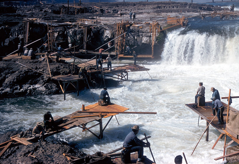

 Indians fishing at Celilo Falls in the early 1950s. All photos courtesy of the Columbia River Inter-Tribal Fish Commission. Top photo, photographer unknown; middle and bottom photos from CRITFC’s Raymond Matheny Collection.
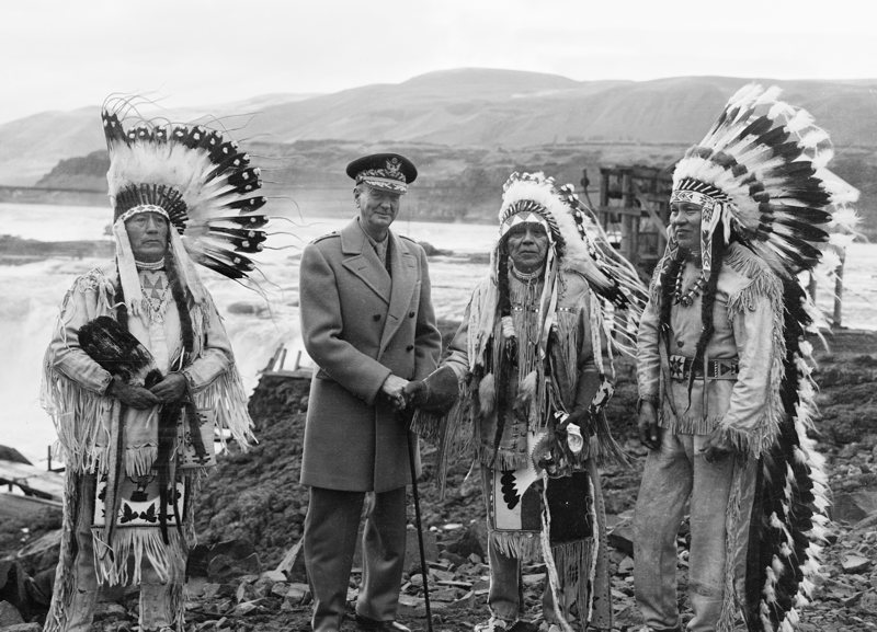
In 1945, U.S. Army General General Jonathan Wainwright, a World War II hero who was born at Fort Walla Walla and who had a life-long interest in the Columbia River, toured the nation and spoke at The Dalles. He requested a tour of Celilo Falls and a meeting with the Indians who fished there. Here, he poses with Charley Quetukhin, left, Wyam Chief Tommy Thompson, with whom he is shaking hands, and Thompson's son Henry. Photo: Everett Olmstead, Historical Photo Archives No. 9305-A4307A