


Overview of cold water refugia efforts in mainstem Columbia
- May 30, 2025
- Kym Buzdygon
At its May 13, 2025, meeting, the Council heard an overview and updates on efforts related to addressing sedimentation and improving cold water refugia between Bonneville and McNary dams, as well as efforts in the Umatilla and Walla Walla Basins. Bill Sharp, Yakama Nation Fisheries Scientist and Jerimiah Bonifer, Umatilla Fisheries Program Manager, presented (watch video | read slides).
Sharp gave a short overview of hydrosystem sedimentation issues, pointing out that prior to Bonneville Dam, 16.4 million tons of sediment were transported out to the plume each year by the Columbia. That number has now dwindled to less than half that amount, despite increased inputs from soil erosion. Instead, some of that sediment is being deposited in tributaries, where it can form a sediment fan or delta that reduces flow and can result in warming water. He pointed out that in addition to the ecological impacts, sedimentation affects tribal fishers between Bonneville and McNary dams by filling in traditional fishing holes and creating hazardous river conditions. Warming waters can also cause harmful algal blooms and higher predation rates on migrating juvenile salmon.
EPA’s Columbia Cold Water Refuges Plan defines a cold water refuge as a tributary that flows at 10 cubic feet per second and is 2 degrees colder than the receiving Columbia River. Steelhead and Fall Chinook are currently the primary users due to their migration window, but as the river continues to warm, other stocks will also likely benefit from these cold water refuges.
The Yakama Nation is coordinating with the Columbia River Inter-Tribal Fish Commission (CRITFC) and the US Army Corps of Engineers on multiple tributary studies, including in the Wind, White Salmon, and Klickitat River Deltas. Cold water refuges are also part of the recent commitments made between the federal government and several states and tribes, with priority project locations listed as Hood River, Columbia River Deltas (Wind, Klickitat, White Salmon, Herman Creek), the Deschutes River, the Umatilla River, and the Walla Walla River.
One study on smolt survival in the Klickitat Delta really highlighted the risks that sedimentation poses to stocks. “We’re losing about 40% of our steelhead from the Klickitat down to Bonneville, and then more precisely, through that delta, we’re losing quite a bit,” said Sharp. “And these are Mid-C[olumbia] listed fish. So, we hope that efforts we take here will help turn the tide through these warm, shallow conditions where there’s a thin sheet of water, avian predators have easy pickings, and pikeminnow and bass pick up the stragglers.”
Another example Sharp gave was the White Salmon Delta Project, following the 2011 removal of Condit Dam. About 15,000 cubic yards of material was excavated from the boat basin and used to elevate 5.5 acres of sandbar, which was then converted to riparian forest.
Bonifer continued the presentation by discussing efforts happening in the Umatilla and Walla Walla River basins to increase and protect cold water. Currently, the area where the Umatilla confluences with the Columbia downstream of McNary Dam is only considered a partial cold water refuge in late August and September, and the nearest downstream refuge is 84 miles away in the Deschutes. Actions being taken include the restoration and protection of thousands of acres of floodplain and riparian habitat designed to slow down and soak up water as the basin changes from more of a snow-based system to a rain-based system.
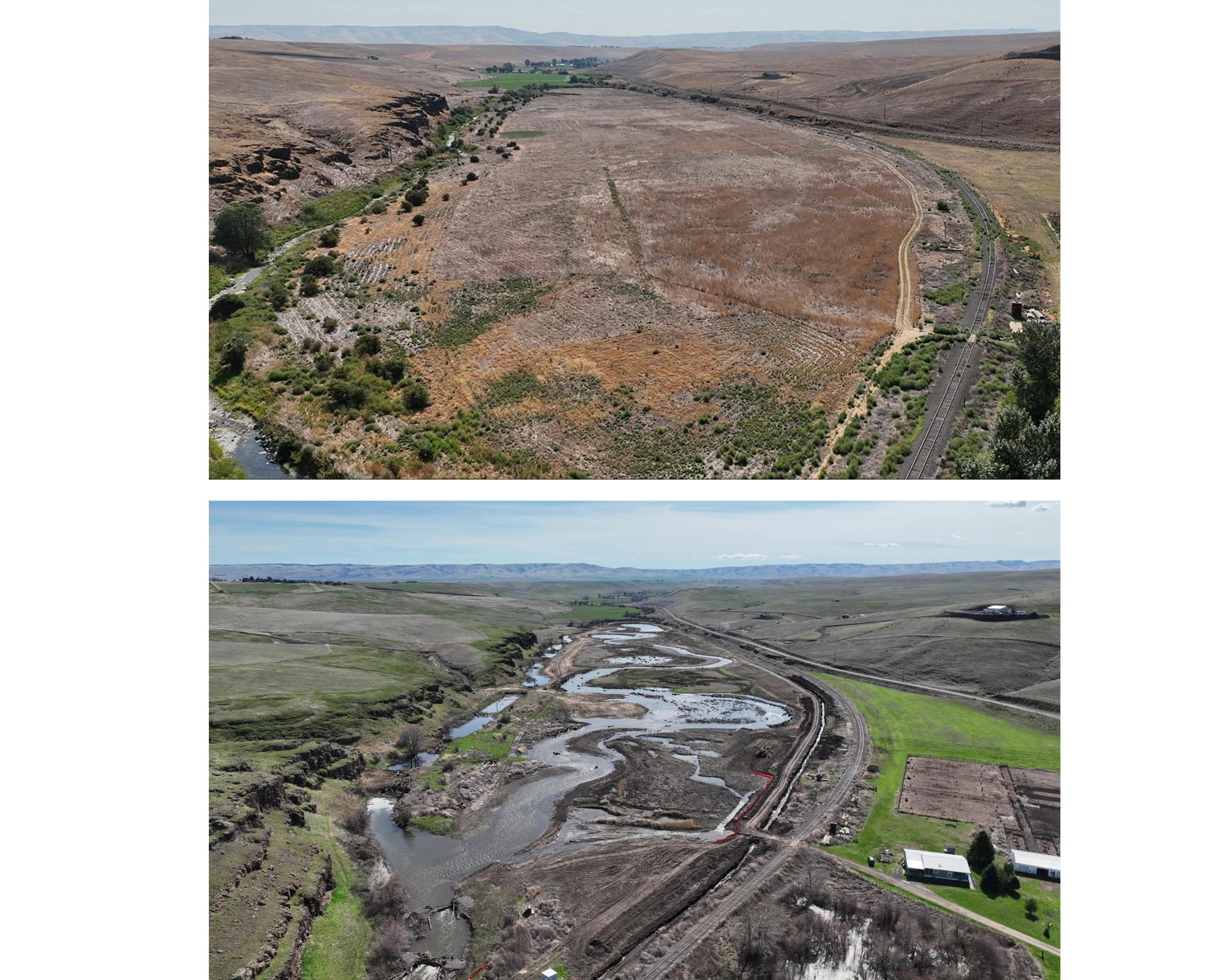
One example Bonifer gave of this work is the Umatilla River-Birch Creek (UmaBirch) conservation easement, located just below Pendleton, OR. Birch Creek produces roughly 40-50% of the ESA-listed Mid C steelhead in the Umatilla Basin. The restoration added channel flow and complexity and included 3.5 cfs of converted instream flow. Other opportunities in the Umatilla Basin include a potential water rights settlement that could double instream flows of cooler water in the summer.
Bonifer also spoke to efforts in the Walla Walla Basin, including connectivity with the Bateman Island causeway removal project and Walla Walla 2050, a collaborative effort to address instream flows.