The Willamette River is the largest tributary of the Columbia in Oregon and the largest river wholly within the state (the Snake, which forms a portion of Oregon’s border with Idaho, is a bigger river but is not wholly within Oregon). Not only is the Willamette a major river, it flows through the most populated part of the state. The Willamette River Basin comprises 11,748 square miles and includes 70 percent of the population of Oregon.
The 4,000-square-mile Willamette Valley, destination of thousands of Oregon Trail emigrants in the 1840s and 1850s, has rich farmland and annually produces about half of all the sales of farm products in the state. The river basin is bordered by the Cascade Mountains on the east, the Coast Range on the west, and the Calapooia Range on the south. The northern end is its discharge into the Columbia 86 miles inland from the ocean. There, the Columbia flows through Oregon’s largest city, Portland, which has an urban-area population of more than 1 million.
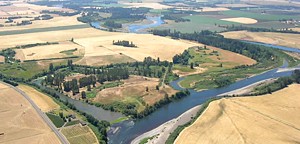
The Willamette basin is about 180 miles long and 100 miles wide; the mainstem of the river is 185 miles long. The Willamette is the 13th largest river by volume in the United States. Largely because of its location between two mountain ranges and its proximity to the ocean and frequent weather systems, the Willamette has more runoff per square mile than any other large river in the lower 48 states.
According to the 2004 Willamette Subbasin Plan, which is part of the Council’s Columbia River Basin Fish and Wildlife Program, there 18 species of native amphibians, 15 species of reptiles, 154 bird species, 69 mammal species, and 31 native fish in the basin. There are 25 major dams in the Willamette basin, including 11 hydropower dams operated by public and private utilities, one multipurpose dam on the Tualatin River, and 13 multipurpose reservoirs (flood control, hydropower, recreation) operated by the U.S. Army Corps of Engineers.
Willamette Falls, about a dozen miles south of Portland, is a horseshoe-shaped, basalt ledge with a drop of 42 feet and is 1,300 feet wide – is the largest in the Northwest by volume (about 31,000 cubic feet per second on average). Over time, human actions altered the falls and the river flow with concrete revetments (beginning in the 1860s, paper mills used water power from the falls), fish ladders, navigation locks (completed in 1873, the oldest west of the Mississippi) and a small hydroelectric plant (Willamette Falls Electric Company, 1888). Historically, the falls also acted as a biological control, as they were passable by salmon and steelhead only in high water, primarily spring Chinook salmon and winter-run steelhead. The fish evolved an early run timing compared to other spring Chinook and steelhead to cross the falls during optimal flow conditions – the falls are lower when the river runs high in the spring.
Below the falls, the river has a very low gradient and is affected by tidal influences and backwater of the Columbia. To allow fish easier passage to spawning areas above the falls, where most of the river basin is located, fish ladders were constructed. The first, in the 1880s, was carved in the rock of the falls. The current ladder was built in 1971 and is operated by the Oregon Department of Fish and Wildlife. The ladders and upstream hatcheries helped establish upriver runs of summer steelhead, coho, and fall Chinook. Historically there were seven independent populations of spring Chinook in the Willamette above the falls in the Upper Willamette River spring Chinook salmon ESU (evolutionarily significant unit): Clackamas, Molalla/Pudding, Calapooia, North Santiam, South Santiam, McKenzie, and Middle Fork Willamette—all eastside tributaries (Meyers et al., 2003). Today, four core populations survive in the Clackamas, North Santiam, McKenzie and Middle Fork Willamette subbasins, which historically sustained large populations and may be able to sustain large populations in the future.
The Willamette Restoration Strategy, 2001, a supplement to the Oregon Plan for Salmon and Watersheds, directs a basinwide strategy to protect and restore fish and wildlife habitat, increase populations of declining species, enhance water quality, and properly manage floodplain areas — all within the context of human habitation and continuing basin growth.
Related: Willamette Falls entry in The Oregon Encyclopedia.